Category: Pacific

  • Roberts Point track, Franz Josef Glacier, South Island, New Zealand


    IMG_0698

    Over the river and through the wood…

    DCIM100GOPRO
    This is a challenging trail, the sign says. People have died hiking it. They do not lie. It is strenuous in parts, and dangerously slippery off and on.
    DCIM100GOPRO
    New Zealand must have a suspension footbridge engineering division!
    DCIM100GOPRO
    Viewing platform at end of trail. Franz Josef glacier. It is receding, like most glaciers today.

    IMG_0692

    On the way back, I saw lots of rocks floating down the river. Rocks?? So I picked one up to take home. Pure, crystal clear glacial ice, probably hundreds of years old. Tasted great!

    BACK

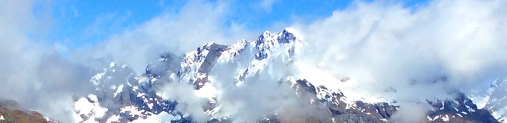
  • Mt. Aspiring Hut and Rob Roy Glacier, South Island, New Zealand

    December 2015

    IMG_0395

    First, you make an hour long drive up a gravel road from Wanaka, fording numerous streams (if the water flow allows).

    IMG_0599

    To the Raspberry Creek Parking Lot (trailhead). Mt. Aspiring off in the distance.

    IMG_0610

    On our way to the Aspiring Hut.

    IMG_0604

    Up the valley next to the glacial melt stream–bridge to Rob Roy Glacier ahead.

    IMG_0611

    A side hike. I’ll do this on the way back.

    IMG_0595 copy

    IMG_0618

    The trail passes through a sheep ranch along the way. Free range sheep?

    IMG_0622

    Several icy streams to cross.

    DCIM100GOPRO
    Beautiful grassy mountain valley, getting closer now.

    IMG_0631


    IMG_0628

    IMG_0629

    Almost there!

    IMG_0638

    IMG_0632

    Aspiring Hut coming up.

    IMG_0633

    Made of local fieldstone.

    IMG_0635

    IMG_0637

    IMG_0598

    This area is a World Heritage Area.

    IMG_0621

    I saw more waterfalls in a few weeks in Fiordland than I have in the whole rest of my life.

    DCIM100GOPRO

    Back down to the Roy Roy Glacier bridge. Time for a little side hike.

    IMG_0613

    DCIM100GOPRO
    Just tiptoe under that big overhanging rock.

    IMG_0640

    IMG_0641

    And you arrive at the hanging edge of the Rob Roy Glacier. It’s big!

    IMG_0646

    Which made for my biggest hiking day in NZ: more than 16 miles and 2500 feet climb.

    Time for a nice hot bath!

    BACK

  • Routeburn track, South Island, New Zealand


    IMG_0476

    Routeburn track is east of Milford Sound.

    IMG_0428

    IMG_0429

    IMG_0505

    IMG_0426

    I never tired of watching the myriad waterfalls.

    IMG_0475

    Made it to Lake MacKenzie!

    IMG_0491

    Lake MacKenzie is lovely, looks almost like a Japanese stone and water garden.

    IMG_0493

    Beautiful, yet cool enough you want a layer.

    IMG_0459

    Climbing out along one side of the valley.

    IMG_0517

    IMG_0584

    IMG_0550

    Climbing up toward Harris Saddle.

    IMG_0561S

    And down the other side. Dramatic mountain landscapes.

    IMG_0569

    Glad I have hefty ankle high mountain boots!

    IMG_0578

    As we drop down to the Routeburn Falls Lodge.

    IMG_0635 IMG_0581

    IMG_0586

    And into the valley below…

    BACK

  • Milford Sound track, South Island, New Zealand

    I began my solo travels in November 2016. It did not seem beneficial to anyone for me to sit at home in Hawai’i alone, yet it did not seem a great weather time to travel elsewhere–until I remembered that November is the end of spring/beginning of summer in…New Zealand!

    So I booked a flight to Auckland. We had hosted Katherine McKenzie from Auckland in 1982 for a year (when she was in high school). I didn’t know her married name, and thought it unlikely I could find her. At the last minute, I googled her name, and found she was practicing medicine in Auckland under her maiden name!

    Connections were made, and we wound up getting together and had lots of fun getting reacquainted. While at Katherine and Jeremy’s home, I made this short video:

    [vc_video link=”https://vimeo.com/173399434″]

    After my week in Auckland, I strapped on my trekking pack, and flew down to Queenstown, South Island.

    The trekking adventure begins on South Island, New Zealand in November of 2015.

    MilfordWide2

    Along Milford Sound track.


    Queenstown
    Queenstown, the entry portal to Fiordland.
    Boat to start of Milford Sound track (trail)
    Boat to start of Milford Sound track (trail). The southwest part of the South Island is called ‘Fiordland’.

    Glade

    First lodge on the Milford Sound track: Glade House.

    On the trail
    On the trail heading up the valley.

    IMG_0224

    Pompolona Lodge ahead. MacKinnon Pass tomorrow.

    Mackinnon Pass looms ahead
    Mackinnon Pass looms ahead.
    Fortunately, no avalanches this time of year--just rockfall
    Fortunately, no avalanches this time of year–just rockfall.

    IMG_0218

    Lots of waterfalls.

    A lot of mossy trail

    A lot of mossy trail to climb.

    After a long climb, we top Mackinnon Pass
    After a long climb, we top Mackinnon Pass.

    IMG_0275

    IMG_0277

    Descending from MacKinnon Pass.

    Milford Sound track gets a lot of rain
    Milford Sound track gets a lot of rain.
    After 35 miles (including side hikes) we get to Sandfly Point!
    After 35 miles (including side hikes) we get to Sandfly Point!
    Where we take a boat down the lake a bit
    Where we take a boat down the lake a bit.
    You can tell it was wet
    You can tell it was wet. Face nets to keep the Sandflies from biting.
    Next morning, a sunny cruise on Milford Sound (a fiord)
    Hot bathes that night. Next morning, a sunny cruise on Milford Sound (a fiord).

    A fine ending to the most storied ‘tramp’ in New Zealand…

    BACK